

Lewis
-
Posts
1,233 -
Joined
-
Last visited
-
Days Won
1
Content Type
Profiles
Forums
Downloads
Events
Gallery
JWTalk Insider
Blogs
Everything posted by Lewis
-
So far on track for second warmest year. June 2025 Global Temperature Update, Third Warmest June on Record +1.33°C👇 Temperature Mean (1880-1920)NASA Current record (2024) (+1.54C) Second record (2023) (+1.38C) +1.52°C👇 For the Year Hottest year (2024) 1.56c Second hottest year (2023) 1.45c +1.52°C👇 Last 12 Months
-
EL NIÑO/SOUTHERN OSCILLATION (ENSO) DIAGNOSTIC DISCUSSION issued by CLIMATE PREDICTION CENTER/NCEP/NWS 10 July 2025 ENSO Alert System Status: Not Active Synopsis: ENSO-neutral is most likely through the late Northern Hemisphere summer 2025 (56% chance in August-October). Thereafter, chances of La Niña conditions increase into the fall and winter 2025-26, but remain comparable to ENSO-neutral. During June 2025, ENSO-neutral continued, with near-average sea surface temperatures (SSTs) prevailing across most of the equatorial Pacific Ocean [Fig. 1]. The latest weekly Niño SST index values ranged from 0.0°C to +0.4°C [Fig. 2]. Subsurface temperature anomalies were weakly positive and nearly unchanged from last month [Fig. 3], with mostly above-average temperatures established along the thermocline [Fig. 4]. Over the east-central and eastern equatorial Pacific Ocean, low-level wind anomalies were easterly and upper-level wind anomalies were westerly. Convection remained enhanced over Indonesia [Fig. 5]. Collectively, the coupled ocean-atmosphere system in the tropical Pacific reflected ENSO-neutral. The IRI predictions indicate ENSO-neutral is most likely through the Northern Hemisphere winter 2025-26 [Fig. 6]. In contrast, the North American Multi-Model Ensemble favors the onset of La Niña conditions during the Northern Hemisphere fall, though lasting a shorter duration than NOAA's requirement of five consecutive overlapping 3-month seasons. While the subsurface equatorial Pacific remains above average, easterly trade winds are predicted to strengthen in the coming month, which could portend cooler conditions. In summary, ENSO-neutral is most likely through the late Northern Hemisphere summer 2025 (56% chance in August-October). Thereafter, chances of La Niña conditions increase into the fall and winter 2025-26, but remain nearly equal to ENSO-neutral [Fig. 7]. This discussion is a consolidated effort of the National Oceanic and Atmospheric Administration (NOAA), NOAA's National Weather Service, and their funded institutions. Oceanic and atmospheric conditions are updated weekly on the Climate Prediction Center web site (El Niño/La Niña Current Conditions and Expert Discussions). A probabilistic strength forecast is available here. The next ENSO Diagnostics Discussion is scheduled for 14 August 2025.
-
Late reply, it affects slightly but not directly, and looks like the shutdown was postponed by a month.
-
That was a typo, I meant Atlantic. Thanks for catching that.
-
Yeah it’s immediate, foreign countries do have their own Satellites with similar capabilities, but the DMSP Satellites were heavily relied on for US when providing models and forecasts as these Satellites use Microwave technologies and can see through clouds and see inside Storms. US will still receive forecasts through the old fashion way, not sure on international forecasts as the Hurricane Hunter Flights never go outside of the Atlantic Ocean. The same with viewing data for the Arctic, could not access data today, can only access through the Japanese Satellites for Sea Ice Extent only. This also comes at time when the Arctic is in a major heatwave right now and the Ice is melting in large numbers. Going to be an interesting year.
-
US Government cuts has now affected the Satellite Data and will be shut down permanently starting June 30th. The shutdown affects Hurricane Forecasts along with Arctic & Antarctica Sea Ice tables/data. For Hurricanes, using Satellites microwaves was crucial because not only did it track the storms but it was able to detect the rapid intensification of these storms. This is huge loss due to its real time weather forecasts and can detect the intensification a lot faster than what the Hurricane Hunter Flights can since they only fly every 6-8 hours, and a lot can happen in that time. article.
-
Sea Ice Extent in the Arctic back to lowest since records began 47 years ago, and is now at 66 days of lowest ice this year. The Peripheral Seas is taking a beating with all the warm air, meanwhile the High Arctic has stalled in melting.
-
ENSO Neutral EL NIÑO/SOUTHERN OSCILLATION (ENSO) DIAGNOSTIC DISCUSSION issued by CLIMATE PREDICTION CENTER/NCEP/NWS 12 June 2025 ENSO Alert System Status: Not Active Synopsis: ENSO-Neutral is likely in the Northern Hemisphere summer 2025 (82% chance in June-August) and may continue into winter 2025-26, though confidence is lower (48% chance of Neutral and 41% chance of La Niña in November-January). In the past month, ENSO-neutral conditions persisted, with sea surface temperatures (SSTs) near average over most of the equatorial Pacific Ocean [Fig. 1]. The latest weekly Niño index values ranged from -0.1°C to +0.4°C [Fig. 2]. Subsurface ocean temperatures were near-to-above average (averaged across 180°-100°W, [Fig. 3]), with above-average subsurface ocean temperatures at depth in the central and western Pacific [Fig. 4]. For the month, low-level winds were easterly over the east-central Pacific, while upper-level winds were mostly near average across the equatorial Pacific Ocean. Convection was enhanced over Indonesia [Fig. 5]. Collectively, the coupled ocean-atmosphere system in the tropical Pacific reflected ENSO-neutral. The IRI and North American Multi-Model Ensemble predictions indicate ENSO-neutral is most likely through the Northern Hemisphere winter 2025-26 [Fig. 6]. The forecast team also continuously favors ENSO-neutral through early 2026, with smaller chances that La Niña could form during winter 2025-26. In summary, ENSO-Neutral is likely in the Northern Hemisphere summer 2025 (82% chance in June-August) and may continue into winter 2025-26, though confidence is lower (48% chance of Neutral and 41% chance of La Niña in November-January; [Fig. 7]). This discussion is a consolidated effort of the National Oceanic and Atmospheric Administration (NOAA), NOAA's National Weather Service, and their funded institutions. Oceanic and atmospheric conditions are updated weekly on the Climate Prediction Center web site (El Niño/La Niña Current Conditions and Expert Discussions). Additional perspectives and analysis are also available in an ENSO blog. A probabilistic strength forecast is available here. The next ENSO Diagnostics Discussion is scheduled for 10 July 2025.
-
Thanks Mike, there are many global issues going on right now and all of them are getting worst, but this one imo takes the cake. Global temperatures are reaching to a point of no return. It’s all timing, by the time the proclamation of peace and security is said, the events that we will experience from the destruction of our ice caps from human caused Global Warming will be felt worldwide. This will no doubt contribute to a great tribulation that we will experience on top of everything else. Within the next 5 years or so we should see an Ice free Arctic.
-
May 2025 Global Temperature Update, Second Warmest May on Record +1.35°C👇 Temperature Mean (1880-1920) Current record (2024) (+1.44C) +1.55°C👇 For the Year Hottest year (2024) 1.56c Second hottest year (2023) 1.45c +1.54°C👇 Last 12 Months
-

Peace and Security, Great Tribulation, Armageddon
Lewis replied to Dhanyel's topic in Secular News in the Mainstream Media
Not really anything new, it’s becoming more talked about for a long time but no one took its seriousness for the long term. Now that long term has arrived. That imbalance that remained on Earth equaled to about 800000 Hiroshima bombs worth of energy each day during the summer of 2023. in June/July 2023, the energy from the sun Earth received was 340.38 w/m2 and the energy radiated back to space was 338.41 with a positive balance of 1.97 m/w2. This year we’re half on the positive balance, but we should expect this to continue to get worse especially during El Niño since it affects the Albedo effect and with the reduction of Aerosols. 1.97 m/w2 is the highest positive imbalance we’ve ever measured since Satellites measurements started. -
I'm going to Canada with my family in June
Lewis replied to Jwanon's topic in Travel, Vacation, & Outdoor Activities
I have to agree with Elijah, trying some poutine is definitely a must for things to eat. As a guidance, Quebec fast food chains have the best poutines there, Belle Province and Lafleur are probably my top two favorites and are in around Saint Catherines which is like the Main Street of Montreal, the other Main Street is Saint Laurent Blvd and thats where Schwartz Deli is. -
I'm going to Canada with my family in June
Lewis replied to Jwanon's topic in Travel, Vacation, & Outdoor Activities
You will love Montreal if you haven’t been there before, I was born there. The food there is amazing, I totally recommend to pay a visit at the Schwartz Deli if you like smoked meats sandwiches. Hope you have fun visiting. -
We are currently second hottest for the year 4 months in, so far we have maintained over 1.5C every month. In order to beat 2024 record year, we would need to stay consistent at 1.54C for each month for the rest of the year. April 2025 Global Temperature Update, Second Warmest April on Record +1.51°C👇 Temperature Mean (1880-1920) Current record (2024) (+1.59C) +1.61°C👇 For the Year Hottest year (2024) 1.56c Second hottest year (2023) 1.45c +1.55°C➖ Last 12 Months
-
I'm going to Canada with my family in June
Lewis replied to Jwanon's topic in Travel, Vacation, & Outdoor Activities
Where in Canada are you visiting? -
EL NIÑO/SOUTHERN OSCILLATION (ENSO) DIAGNOSTIC DISCUSSION issued by CLIMATE PREDICTION CENTER/NCEP/NWS 8 May 2025 ENSO Alert System Status: Not Active Synopsis: ENSO-neutral is favored through the Northern Hemisphere summer 2025 (74% chance during June-August), with chances exceeding 50% through August-October 2025. In April 2025, ENSO-neutral continued, with near-average sea surface temperatures (SSTs) covering most of the equatorial Pacific Ocean [Fig. 1]. All of the latest weekly Niño index values were near zero, ranging from -0.2°C to +0.1°C [Fig. 2]. Subsurface temperatures were mostly near average in the central and eastern Pacific Ocean [Fig. 3], with above-average subsurface temperatures remaining at depth in the western Pacific [Fig. 4]. For the month, low-level and upper-level winds were near average across the equatorial Pacific. Convection remained suppressed near and west of the Date Line and was enhanced near Indonesia [Fig. 5]. Collectively, the coupled ocean-atmosphere system was ENSO-neutral. The IRI and North American Multi-Model Ensemble anticipate ENSO-neutral will continue through the Northern Hemisphere summer and early autumn 2025 [Fig. 6]. The forecast team also favors ENSO-neutral, especially through the summer, with chances nearing 50% during the autumn. The uncertainty increases at longer time horizons, with a 46% chance of ENSO-neutral and a 41% chance of La Niña during November 2025 - January 2026 (chances of El Niño are under 15%). In summary, ENSO-neutral is favored through the Northern Hemisphere summer 2025 (74% chance during June-August), with chances exceeding 50% through August-October 2025 [Fig. 7]. This discussion is a consolidated effort of the National Oceanic and Atmospheric Administration (NOAA), NOAA's National Weather Service, and their funded institutions. Oceanic and atmospheric conditions are updated weekly on the Climate Prediction Center web site (El Niño/La Niña Current Conditions and Expert Discussions). Additional perspectives and analysis are also available in an ENSO blog. A probabilistic strength forecast is available here. The next ENSO Diagnostics Discussion is scheduled for 12 June 2025.
-
The Mediterranean Sea became an emissions control area as of May 1, any ship operating in the Mediterranean Sea now must have Sulphur content no more than 0.10%. Reduced from 0.50% https://www.rfi.fr/en/international/20250501-ships-switch-to-cleaner-fuel-as-mediterranean-becomes-low-emissions-zone When Aerosols are removed, we will see Global Warming get worst, because the heat is hidden from the Aerosols. Global temperatures will continue to rise and new records will continue to broken. In April, Siberia broke records when half of the month had temperatures of exceeding 30C +, that never happened before. Today, in London, hottest start for May. Asia is expecting record heat in the coming days/weeks.
-
The cooling of La Niña last month barely made a dent in our reduced Global Temperatures, this also suggests that Global Warming is so much stronger than the cooling made by man made Aerosol's. Every month so far this year we are over 1.50C and can expect at least 0.2C of temperature rise during Neutral phase which could last for the rest of the year. If we don’t break another record year, 2025 will most likely be the second hottest. March 2025 Global Temperature Update, Second Warmest March on Record +1.65°C👇 Temperature Mean (1880-1920) Current record (2024) (+1.68C) +1.64°C👆 For the Year Hottest year (2024) 1.56c Second hottest year (2023) 1.45c +1.55°C👇 Last 12 Months
-
We are in ENSO Neutral, Global temperature will increase by 0.2C now that La Nina’s cooling will disappear. EL NIÑO/SOUTHERN OSCILLATION (ENSO) DIAGNOSTIC DISCUSSION issued by CLIMATE PREDICTION CENTER/NCEP/NWS 10 April 2025 ENSO Alert System Status: Final La Niña Advisory Synopsis: ENSO-neutral is favored during the Northern Hemisphere summer, with a greater than 50% chance through August-October 2025. In March 2025, ENSO-neutral conditions returned, with below-average sea surface temperatures (SSTs) weakening in the central and east-central equatorial Pacific Ocean [Fig. 1]. The westernmost Niño index values were near zero, while positive index values persisted in the easternmost Niño-3 and Niño-1+2 regions [Fig. 2]. Below-average subsurface temperatures weakened [Fig. 3], but negative anomalies continued in the central equatorial Pacific, extending to 250m depth [Fig. 4]. A shallow layer of above-average subsurface temperatures continued in the far eastern equatorial Pacific. Low-level wind anomalies remained easterly over the western and central Pacific, while upper-level wind anomalies were westerly over the central Pacific. Convection was suppressed around the Date Line and was enhanced near Indonesia [Fig. 5]. The traditional and equatorial Southern Oscillation indices were positive. Collectively, the coupled ocean-atmosphere system reflected ENSO-neutral conditions. The IRI and North American multi-model ensemble indicate ENSO-neutral will continue through the summer [Fig. 6]. The forecast team also favors ENSO-neutral, with chances well over 50% through summer 2025. Because of reduced forecast accuracy in the spring, the uncertainty increases at longer time horizons, with a 43% chance of ENSO-neutral and a 38% chance of La Niña during November 2025 - January 2026 (chances of El Niño are under 20%). In summary, ENSO-neutral is favored during the Northern Hemisphere summer, with a greater than 50% chance through August-October 2025 [Fig. 7]. This discussion is a consolidated effort of the National Oceanic and Atmospheric Administration (NOAA), NOAA's National Weather Service, and their funded institutions. Oceanic and atmospheric conditions are updated weekly on the Climate Prediction Center web site (El Niño/La Niña Current Conditions and Expert Discussions). Additional perspectives and analysis are also available in an ENSO blog. A probabilistic strength forecast is available here. The next ENSO Diagnostics Discussion is scheduled for 8 May 2025.
-
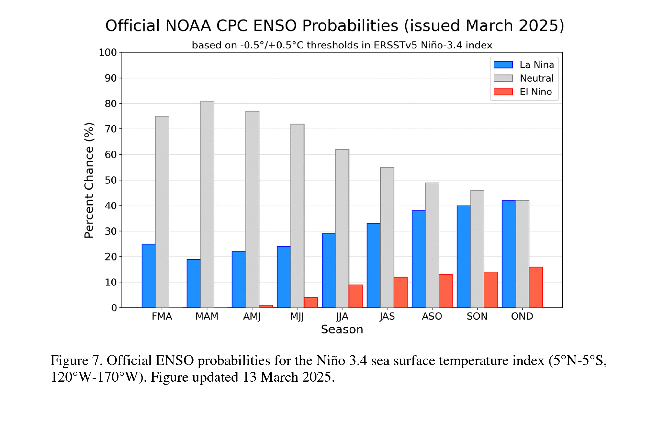
March was La Niña. Now heading to Neutral. EL NIÑO/SOUTHERN OSCILLATION (ENSO) DIAGNOSTIC DISCUSSION issued by CLIMATE PREDICTION CENTER/NCEP/NWS 13 March 2025 ENSO Alert System Status: La Niña Advisory Synopsis: ENSO-neutral is favored to develop in the next month and persist through the Northern Hemisphere summer (62% chance in June-August 2025). During February 2025, below-average sea surface temperatures (SSTs) weakened in the central and east-central equatorial Pacific Ocean [Fig. 1]. All weekly Niño indices reflected this decline, with near-to-below average values lingering in the Niño-3.4 and Niño-4 regions [Fig. 2]. Significant coastal warming was evident near South America, with the latest Niño-1+2 value at 1.6°C. This warming, however, was shallow (in the upper 50m) and was associated with low-level westerly wind anomalies over the eastern Pacific. Below-average subsurface temperatures also weakened [Fig. 3], but negative anomalies persisted at depth in the eastern Pacific and extended down to 200m in the central Pacific [Fig. 4]. Tropical Pacific atmospheric anomalies continued to indicate La Niña conditions. Low-level wind anomalies remained easterly over the western and central Pacific, while upper-level wind anomalies were westerly over the east-central Pacific. Convection was suppressed around the Date Line and was enhanced near Indonesia [Fig. 5]. The traditional and equatorial Southern Oscillation indices were positive. Collectively, the coupled ocean-atmosphere system reflected weakening La Niña conditions and a trend toward ENSO-neutral. The IRI and North American multi-model ensemble predicts a transition to ENSO-neutral in the coming season [Fig. 6]. The forecast team concurs and predicts ENSO-neutral, with chances greater than 50% through July-September 2025. As is typical for forecasts made in the spring, there is large forecast uncertainty at longer time horizons, with no outcome exceeding a 50% chance (chances of El Niño are the lowest). In summary, ENSO-neutral is favored to develop in the next month and persist through the Northern Hemisphere summer (62% chance in June-August 2025; [Fig. 7]). This discussion is a consolidated effort of the National Oceanic and Atmospheric Administration (NOAA), NOAA's National Weather Service, and their funded institutions. Oceanic and atmospheric conditions are updated weekly on the Climate Prediction Center web site (El Niño/La Niña Current Conditions and Expert Discussions). Additional perspectives and analysis are also available in an ENSO blog. A probabilistic strength forecast is available here. The next ENSO Diagnostics Discussion is scheduled for 10 April 2025.

-
A major SSW is underway in the Arctic, ice is at its minimum for sometime now and should see more sea ice melt along with Greenland. Melt season starts in a couple of days. Blue Ocean Event this year? https://ds.data.jma.go.jp/tcc/tcc/products/clisys/STRAT/
-
Mistake on January’s update, suppose to say 1.70C for mean temperature and year. February may appear cooler but we are over 1.5C threshold which is now our new normal. February 2025 Global Temperature Update, Third Warmest February on Record +1.56°C👇 Temperature Mean (1880-1920) Current record (2024) (+1.74C) Second (2016) (+1.66C) +1.63°C👇 For the Year +1.56°C➖ Last 12 Months
-
Love tracking these icebergs. Heres some info about iceberg A23a that calved in 1986. https://eros.usgs.gov/earthshots/the-1986-filchner-calvin
-
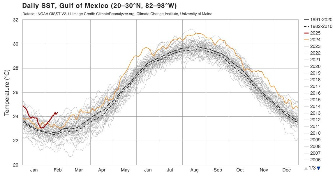
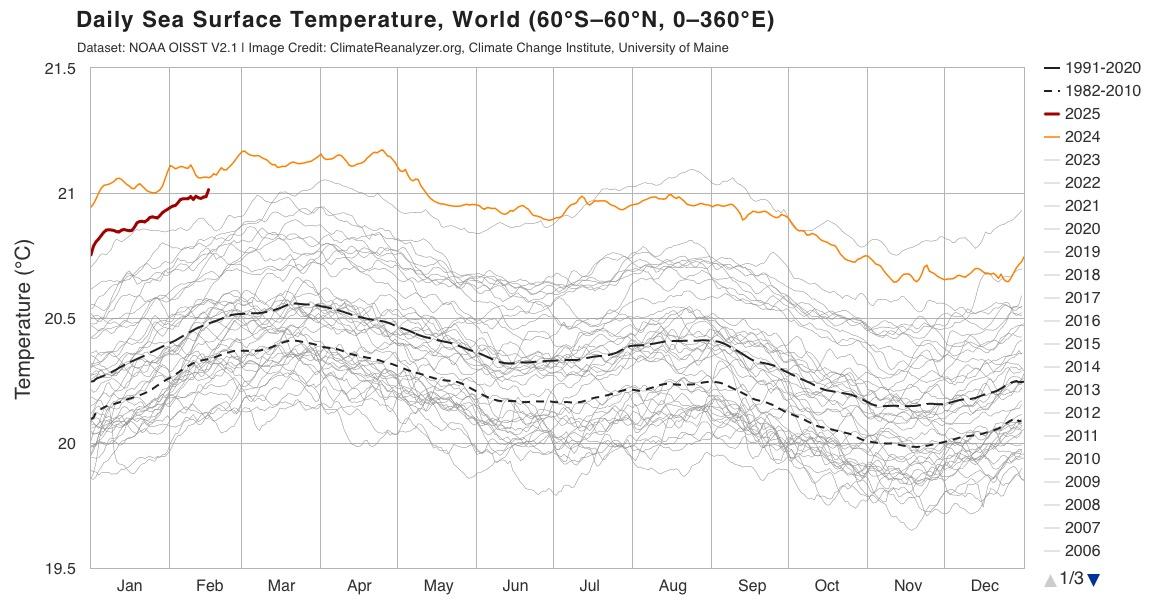
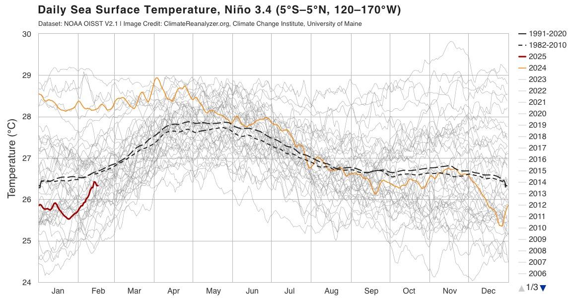
Oceans are cooking, Gulf of Mexico at record high. World SST rising towards hottest, Nino 3.4 is rising quick. Sign of another record year?
-
Global Warming has definitely accelerated and will continue to climb in temperature. +2.0 C temp is on its way, most likely around 2030 by estimates. January 2024 with an El Niño beat January 2025 with La Niña for warmest on record. May 1st new shipping regulations to cut 80% emissions in the mediterranean goes into effect. January 2025 Global Temperature Update, Warmest January on Record +1.59°C👆 Temperature Mean (1880-1920) +1.59°C➖ For the Year +1.56°C➖ Last 12 Months


About JWTalk.net - Jehovah's Witnesses Online Community
Since 2006, JWTalk has proved to be a well-moderated online community for real Jehovah's Witnesses on the web. However, our community is not an official website of Jehovah's Witnesses. It is not endorsed, sponsored, or maintained by any legal entity used by Jehovah's Witnesses. We are a pro-JW community maintained by brothers and sisters around the world. We expect all community members to be active publishers in their congregations, therefore, please do not apply for membership if you are not currently one of Jehovah's Witnesses.