

More4me2do
-
Posts
669 -
Joined
-
Last visited
More4me2do's Achievements
")


-
 Cruzer reacted to a post in a topic:
NW Scheduler/Publisher - Updates, Support, and Suggestions
Cruzer reacted to a post in a topic:
NW Scheduler/Publisher - Updates, Support, and Suggestions
-
Marky reacted to a post in a topic:
NW Scheduler/Publisher - Updates, Support, and Suggestions
-
jwhess reacted to a post in a topic:
NW Scheduler/Publisher - Updates, Support, and Suggestions
-
 Excellent Good News, with the latest update of NWS the Satellite view of territories is working again. The best map service is the MapBox Satellite as the other map service ThinkGeo Satellite is not as clear and sharp, plus my first quick check shows in one territory finished homes in an undeveloped area. So, it looks like that an update for the ThinkGeo Satellite map service is needed. Thanks to the Devs for getting such a quick fix for the territory module.
 -
Cruzer reacted to a post in a topic:
NW Scheduler/Publisher - Updates, Support, and Suggestions
-
Cruzer reacted to a post in a topic:
NW Scheduler/Publisher - Updates, Support, and Suggestions
-
Cruzer reacted to a post in a topic:
NW Scheduler/Publisher - Updates, Support, and Suggestions
-
jwhess reacted to a post in a topic:
NW Scheduler/Publisher - Updates, Support, and Suggestions
-
Just installed the minor update this morning and I noticed that the Bing Satellite map as well as the Bing map dark was removed from the available map providers. That is a real concern as it basically makes the assigning of new addresses now more guess work as to where the residences are. I understand that there may be an additional expense for map services, but if at all make it an option to add for an additional fee the Bing Satellite map.
-
jwhess reacted to a post in a topic:
NW Scheduler/Publisher - Updates, Support, and Suggestions
-
I could now add an address to the territory, but the Bing Satellite map is not displaying and you sort of have to guess where the home is. Does that have to do with any API or paid service for the satellite map to be displayed?
-
jwhess reacted to a post in a topic:
NW Scheduler/Publisher - Updates, Support, and Suggestions
-
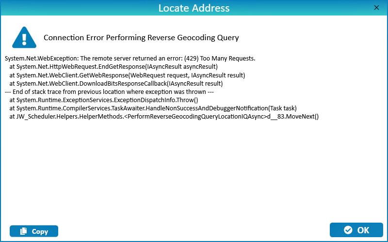
I updated to the latest version and everything is working as it is supposed to except when trying to add an address to a territory I get this error message and this has been for a few hours now. Request: System.Net.WebException: The remote server returned an error: (429) Too Many Requests. at System.Net.HttpWebRequest.EndGetResponse(IAsyncResult asyncResult) at System.Net.WebClient.GetWebResponse(WebRequest request, IAsyncResult result) at System.Net.WebClient.DownloadBitsResponseCallback(IAsyncResult result) --- End of stack trace from previous location where exception was thrown --- at System.Runtime.ExceptionServices.ExceptionDispatchInfo.Throw() at System.Runtime.CompilerServices.TaskAwaiter.HandleNonSuccessAndDebuggerNotification(Task task) at JW_Scheduler.Helpers.HelperMethods.<PerformReverseGeocodingQueryLocationIQAsync>d__83.MoveNext() Result: https://us1.locationiq.com/v1/reverse?key=pk.00eaaac3ec9aeda0701ef179d10ac280&lat=38.6257851145725&lon=-76.9406257339515&format=json

-
Cruzer reacted to a post in a topic:
NW Scheduler/Publisher - Updates, Support, and Suggestions
-
In the first comment on this page I quoted from the US Addendum where it says: "3. The body of elders may decide whether to retain Congregation’s Publisher Records (S-21) electronically or in printed form." So if you are in Europe or a country that has GDPR or Electronic Data Protection laws than your usage of personal information is governed by those laws. For example in the ministry in those countries you can't write down a person's contact details and pass this on to someone else. In addition, I believe that publishers have to give their consent to having a S-21 form kept on file. The conclusion is this you have to go by what the local laws are just as you go by the local customs and culture and as a result you have different instructions in different branches. That is why I said in the top comment, "Much easier in the USA" and that is from the USA addendum, which does not apply to other parts of the world.
-
Much easier in the USA sfla-E Us 10/23 Correspondence and Records 3. The body of elders may decide whether to retain Congregation’s Publisher Records (S-21) electronically or in printed form. 4. There is no objection to using online storage services for nonconfidential documents, such as those containing information that would be posted on the information board. However, information of a sensitive or confidential nature, including judicial matters, should never be stored online.
-
More4me2do reacted to a post in a topic:
NW Scheduler/Publisher - Updates, Support, and Suggestions
-
More4me2do reacted to a post in a topic:
NW Scheduler/Publisher - Updates, Support, and Suggestions
-
Did you ever find out if NWS works on the snapdragon plus /elite processors? I am contemplating getting the just announced Surface Pro 12 which has the snapdragon plus processor.
-
Didn't really know where to post this, but I am contemplating to get the new Microsoft Surface Pro 12 with the Snapdragon X Plus processor using Windows 11 Pro. Does anyone heard of any compatibility issues running NW Scheduler on these non Intel processor Surface Pro devices?
-
Yes all the other blue color arrows work it is just the memorial one. On the home page under events the memorial displays properly.
-
A HUGE request to the developers Is there any way that some houses can receive a special color selection for being available ONLY to the elderly and infirm? Let me explain. All the available homes in a territory have the color and can be worked, however some of the houses are not suitable for the elderly and infirm because of many steps or a steep walkway incline. I would like to mark some houses prior to our ministry in a different color than blue which signals these are ONLY to be worked by the elderly and infirm with using the normal status changes. I know I am able to use a work around by using one of the custom buttons and mark those houses as Infirm and then let the publishers work them as normal. However after completing the territory I would have to keep track of which ones were for the infirm. Surely this is a very common occurrence in the congregations where in some territories there are homes that can be easily accessed by the elderly and infirm and since the houses don't change it would be nice to keep track of them.
-
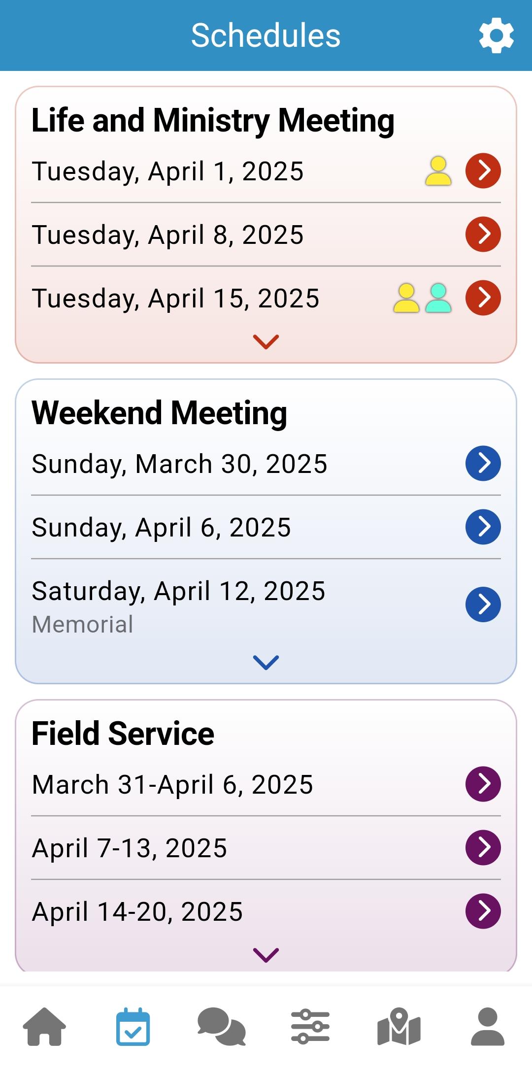
These are my screen shots using Samsung S21 and latest Android and NWP versions for the device. Schedules Page Clicking Blue Arrow
-
I have the latest versions just like you have and my home page looks like yours, but my Schedules page does have the entry: Saturday April 12, 2025 Memorial However when clicking the writing or the blue right arrow, than just a dark grey page displays and when clicking the back arrow on the bottom of my Samsung Android phone the following error message displays: Error Occurred: Null check operator used on a null value. Not a big deal as the home page display for the memorial works fine. Mind you though I updated an April 2 version from the play store.
-
I presume you will go from a map to Digital addresses. What I did is, I took one territory and created a portion of it as a test territory and digitized the addresses. Labeled it as number 999 and gave it the name Testing. Made it available to the whole congregation so that the publishers could experiment with it to their hearts delight, what it is like to change the status according to what happened at the address. You need this when the BofE decides to go with this method of working the territory. I am very sure they will agree as it is a game changer in every which way.
-
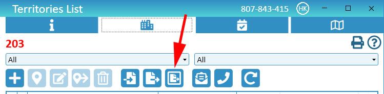
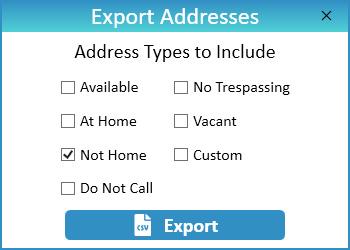
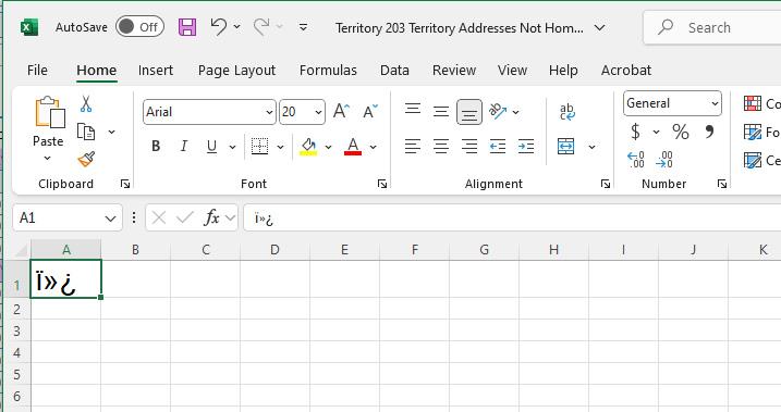
Thanks for trying to help. But the export selected addresses is busted, not working a definite coding problem. The size of the CSV file is 1k which indicates it should have data in it. It is not wrongly formatted for Exel as Notepad shows it is empty and has no data. What you suggested as an option is what I have done as a work around. Export ALL data, then select the status column and sort it alphabetically which puts the Not At Homes and the No Trespassing at the very end of the sheet. Delete all other rows and then create a report of ALL Not At Homes and No Trespassing and pass them on to the Phone witnessing and Letter Writing brothers. Thanks for your help and with the work around I got a temporary solution. Just wanted to pass this on to the developers, because It should not be that difficult to take all the addresses and then parse them with the criteria that is ticked in the selection box.
-
Reporting an error with exporting selected addresses from a territory. After finishing our 1st campaign territory, I wanted to export just the not at homes and followed this procedure: Clicking on the export selected addresses: The export was successful and saved the addresses in file Territory 203 Territory Addresses Not Home.csv However when I open the file in Excel it only has one field with data which looks like junk. I can export all Addresses and then just select the Not At Homes, but I thought to bring this to the attention of the developers.


About JWTalk.net - Jehovah's Witnesses Online Community
Since 2006, JWTalk has proved to be a well-moderated online community for real Jehovah's Witnesses on the web. However, our community is not an official website of Jehovah's Witnesses. It is not endorsed, sponsored, or maintained by any legal entity used by Jehovah's Witnesses. We are a pro-JW community maintained by brothers and sisters around the world. We expect all community members to be active publishers in their congregations, therefore, please do not apply for membership if you are not currently one of Jehovah's Witnesses.