

Lewis
-
Posts
1,334 -
Joined
-
Last visited
-
Days Won
1
Lewis's Achievements
")


-
Latest projection made by NMME is that earth will reach about +1.9C - +2.5C in temperature above preindustrial each month next year, Hansen projects this very sharp rise in temperature will start even earlier in the next couple of months once the Super El Niño kicks into gear.
-
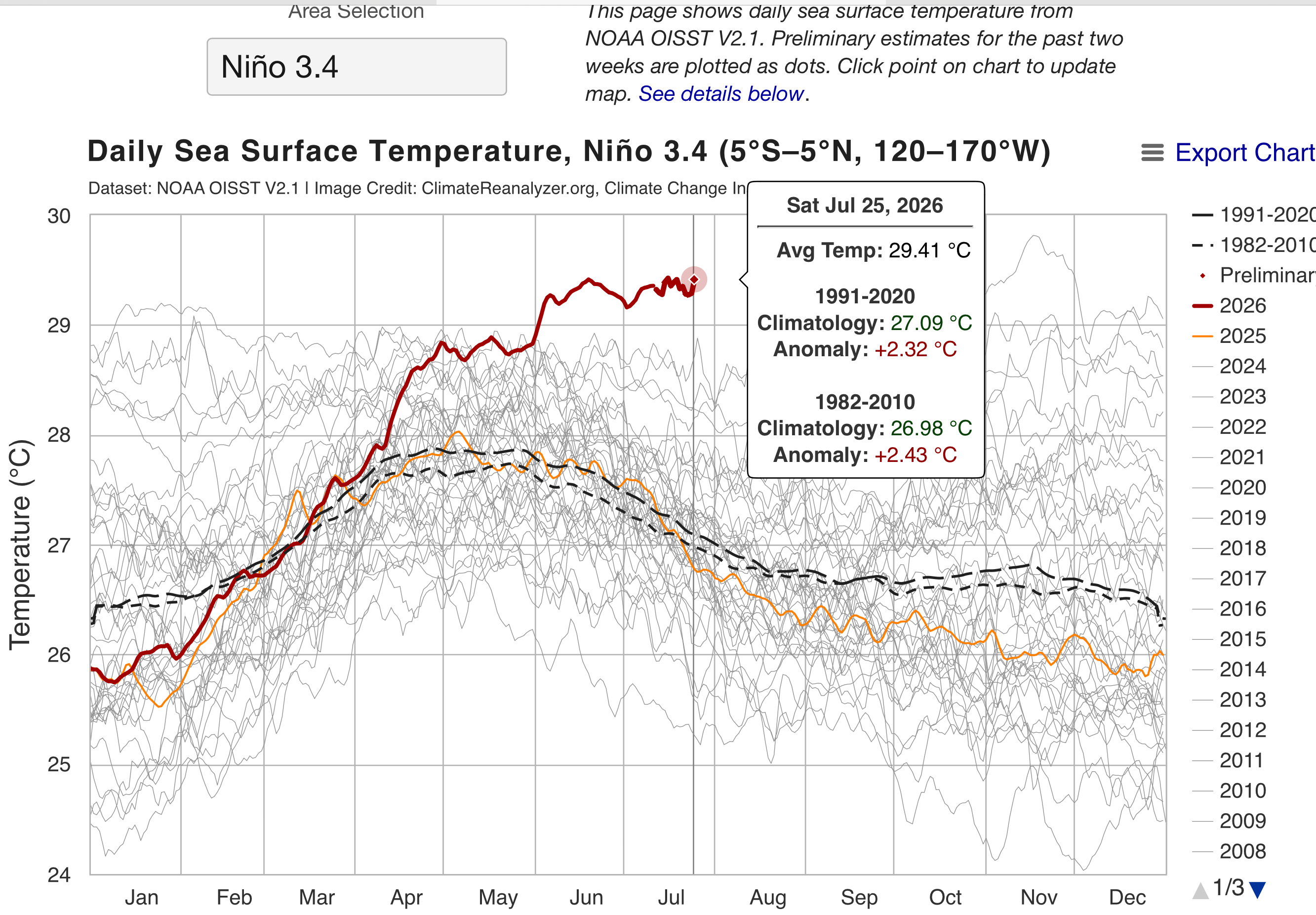
El Niño is now at +2.32C creeping closer to strongest ever recorded in human history (+2.75C), it is forecast to surpass and be around +3.6C or stronger. Get ready for wild weather this year and next year especially.

-
Yeah too early for sure on the assessment, the bad news is, this will only get worst, already at 380,000 evacuated. If these heatwaves keep coming, it will only fuel this enormous wildfire.
-
From what I read that this movie is violent and intense, I also read that people rate this as a soft rated R movie because its not as “Gory”, no matter how I look at it, I cant stand watching this type of violence, its not entertaining to me and conscience tells me to stay away. We have been exposed to this form of entertainment for so long I think we have become inured to this type of content as a society.
-
Wildfires in France and Spain out of control, at least 220,000 people evacuated so far. https://www.bbc.com/news/articles/czjlenp0xk8o British Columbia Wildfires also getting bad, couple of Highways were closed. Anyone here have information about how the brothers/sisters are doing?
-
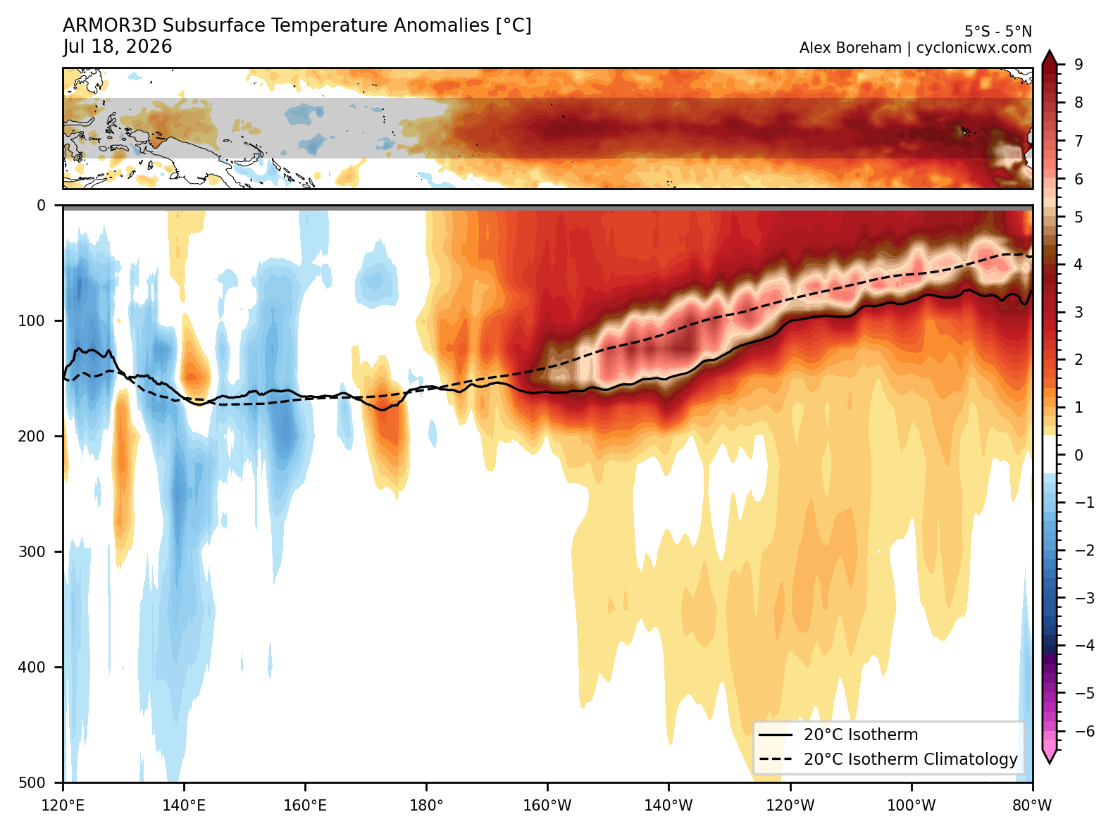
The Y axis has been increased to 10C above normal now on this chart to show the true heat that is coming out of the Ocean, going to be a rough winter and next year coming.
-
Correction on the June update, June 2024 still holds the warmest title, NASA made an update for June 2024 to +1.52C so that makes June 2026 Second Warmest. I have a revised corrected list now. We should start seeing large climate impact soon from this Super El Niño , there’s a strong chance now that 2026 will beat 2024 as warmest.
-
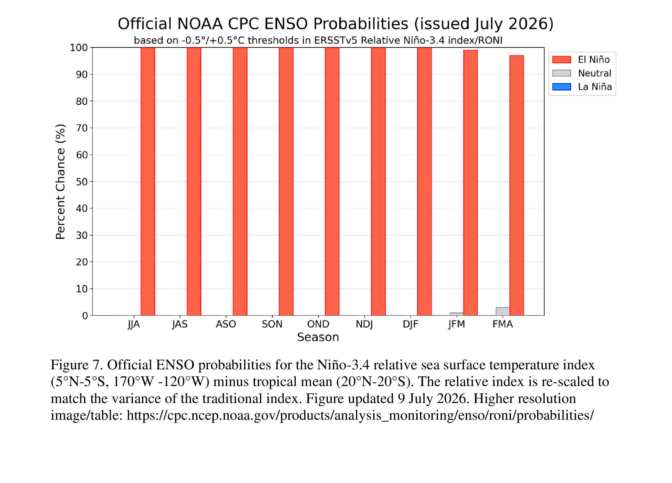
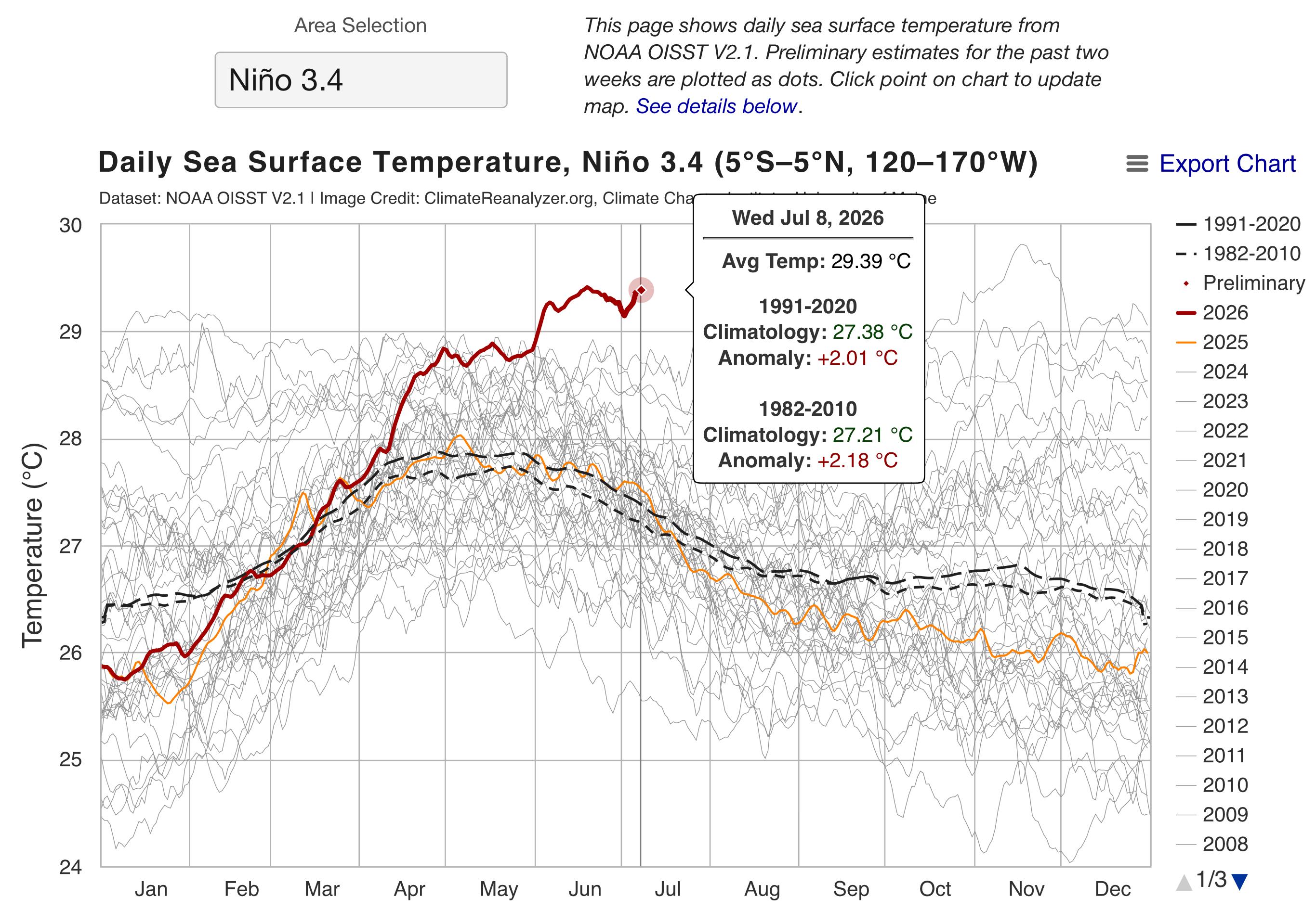
The earliest we reached Super El Niño Status was in August 30, 1997 until we broke that record two days ago on July 8th, 2026. Forecast plumes are predicting between +3.0C and +4.0C above average for Earth on top of the +1.5C that we have accumulated since pre-industrial, which are temperatures that we have never seen before. The extreme weather that is coming will be historical. EL NIÑO/SOUTHERN OSCILLATION (ENSO) DIAGNOSTIC DISCUSSION issued by CLIMATE PREDICTION CENTER/NCEP/NWS 9 July 2026 ENSO Alert System Status: El Niño Advisory Synopsis: El Niño continues and will strengthen through the end of the year, with a 97% chance it will persist through early spring 2027. El Niño strengthened over the past month, with a large area of sea surface temperature anomalies in excess of +1.0°C across the central and eastern equatorial Pacific [Fig. 1]. The latest weekly Niño-3.4 index value was +1.2°C, with the westernmost (Niño-4) and easternmost (Niño-1+2) indices at +0.5°C and +2.7°C, respectively [Fig. 2]. The equatorial subsurface temperature index (average from 180°-100°W) increased [Fig. 3], as a recent downwelling Kelvin wave deepened the thermocline and raised temperatures in the eastern Pacific [Fig. 4]. Low-level westerly wind anomalies and upper-level easterly wind anomalies were observed over the western and central equatorial Pacific. Convection was enhanced over the central and east-central equatorial Pacific and was suppressed over Indonesia [Fig. 5]. The traditional and equatorial Southern Oscillation indices were significantly negative. Collectively, the coupled ocean-atmosphere system reflected a strengthening El Niño. The North American Multi-Model Ensemble (NMME) average, including the NCEP CFSv2 [Fig. 6], forecasts El Niño to intensify through 2026. Alongside model forecasts, a strong coupling of the atmospheric and oceanic circulation across the Pacific contributes to very high confidence that El Niño will continue through early 2027 [Fig. 7]. There is an 81% chance of a very strong El Niño during October-December [Fig. 8] that would rank among the largest El Niño events in the historical record going back to 1950. Even the strongest El Niño events do not lead to the typical impact everywhere, but stronger events can more significantly tilt the odds in favor of expected outcomes (see CPC outlooks for probabilities of seasonal anomalies). In summary, El Niño continues and will strengthen through the end of the year, with a 97% chance it will last through early spring 2027. This discussion is a consolidated effort of the National Oceanic and Atmospheric Administration (NOAA), NOAA's National Weather Service, and their funded institutions. Oceanic and atmospheric conditions are updated weekly on the Climate Prediction Center web site (El Niño/La Niña Current Conditions and Expert Discussions). A probabilistic strength forecast is available here. The next ENSO Diagnostics Discussion is scheduled for 13 August 2026.
-
June 2026 was hottest on record beating June 2024. From June 2023 to July 2024 for 14 consecutive months, earth broke records for warmest months. We will most likely see that record streak extend. June 2026 Global Temperature Update, Warmest June on Record +1.51°C Temperature Mean June (1880-1920)NASA Current Record (2026) (+1.51C) +1.48°C👆 For the Year Hottest year (2024) 1.56c Second hottest year (2025) 1.46c Third hottest year (2023) 1.45c +1.44°C👆 Last 12 Months
-
We have crossed the +2.0C (+2.01C) and Earth is now in a Very Strong (Super) El Niño status. Will take a few months before we start feeling the maximum effects of it.
-
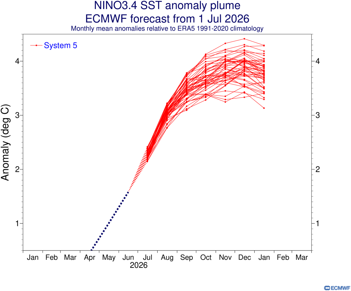
Latest forecast on Nino 3.4, a bit stronger than June’s forecast.
-
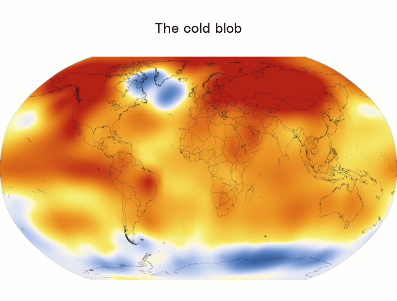
A study released a couple of years ago shows there is a link between Arctic Ice melt and European heatwaves and the coming heatwaves in the US/Canada, and the cold blob that is building by Greenland is all connected. Anthropogenic Global Warming is the blame. https://wcd.copernicus.org/articles/5/109/2024/wcd-5-109-2024.pdf https://www.science.org/content/article/cold-blob-arctic-meltwater-may-be-causing-european-heat-waves
-
 Over 1k Deaths so far and 50k missing latest data
 -
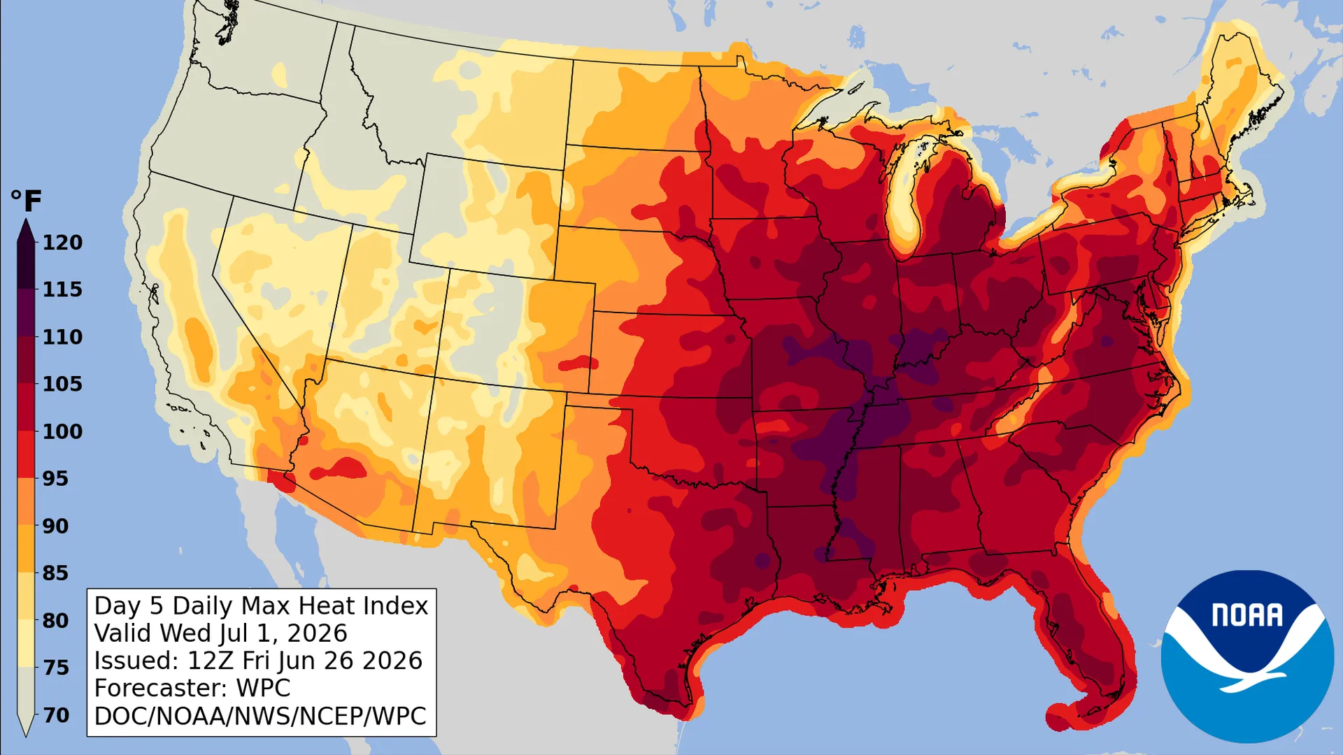
Significant, dangerous heat wave expected next week for the Central to Eastern U.S A dangerous heat dome is expect on the east coast next week according to NOAA. A temperature range between 90-110 with overnight lows to also be very warm bringing little relief.
-
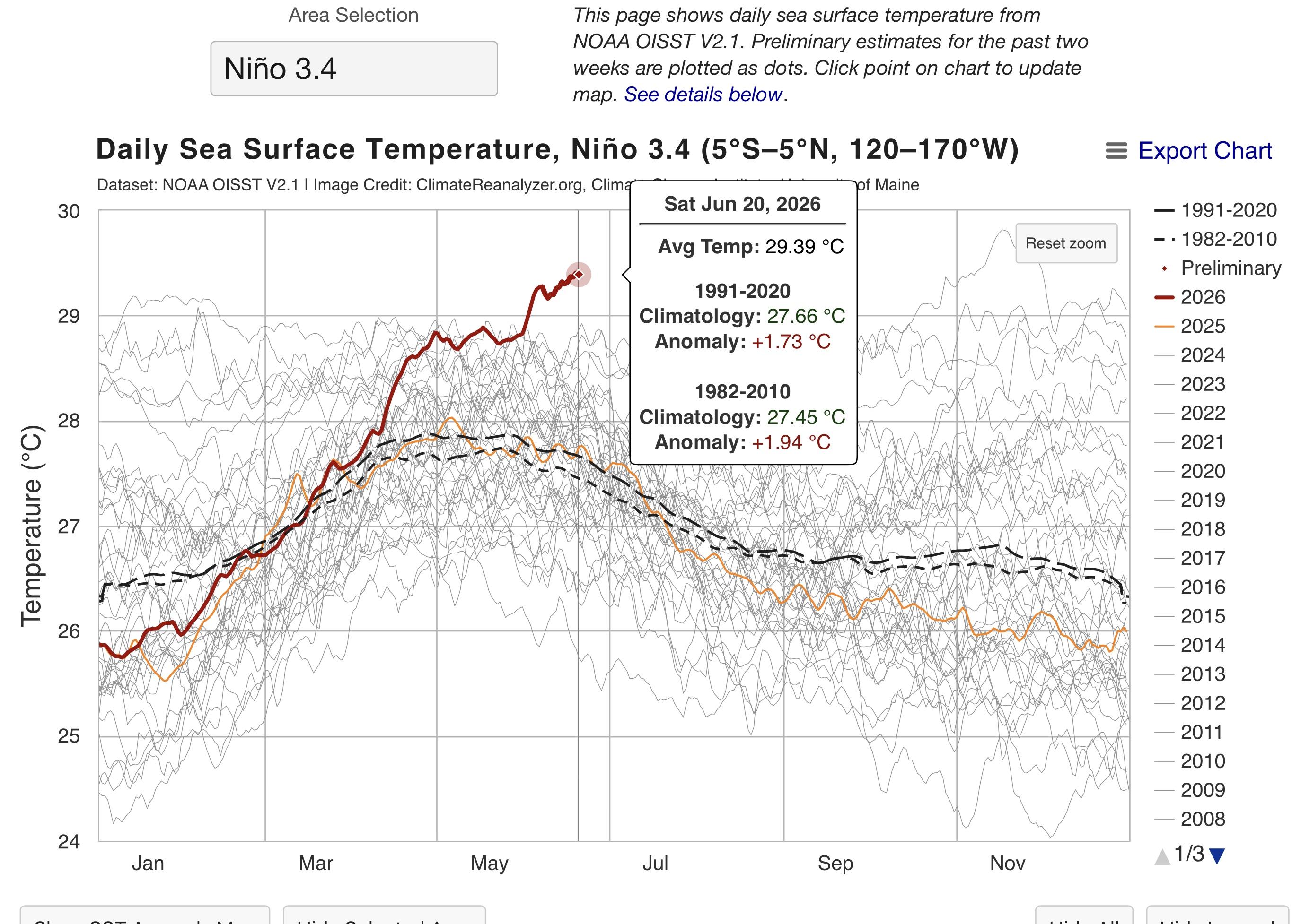
El Niño is at +1.73C as of Saturday, getting close to a Very Strong or Super El Niño Strength (+2.0C).


4 Followers


About Lewis

- Birthday October 29
Recent Profile Visitors
5,190 profile views


About JWTalk.net - Jehovah's Witnesses Online Community
Since 2006, JWTalk has proved to be a well-moderated online community for real Jehovah's Witnesses on the web. However, our community is not an official website of Jehovah's Witnesses. It is not endorsed, sponsored, or maintained by any legal entity used by Jehovah's Witnesses. We are a pro-JW community maintained by brothers and sisters around the world. We expect all community members to be active publishers in their congregations, therefore, please do not apply for membership if you are not currently one of Jehovah's Witnesses.