

Lewis
-
Posts
1,327 -
Joined
-
Last visited
-
Days Won
1
Content Type
Profiles
Forums
Downloads
Events
Gallery
JWTalk Insider
Blogs
Everything posted by Lewis
-
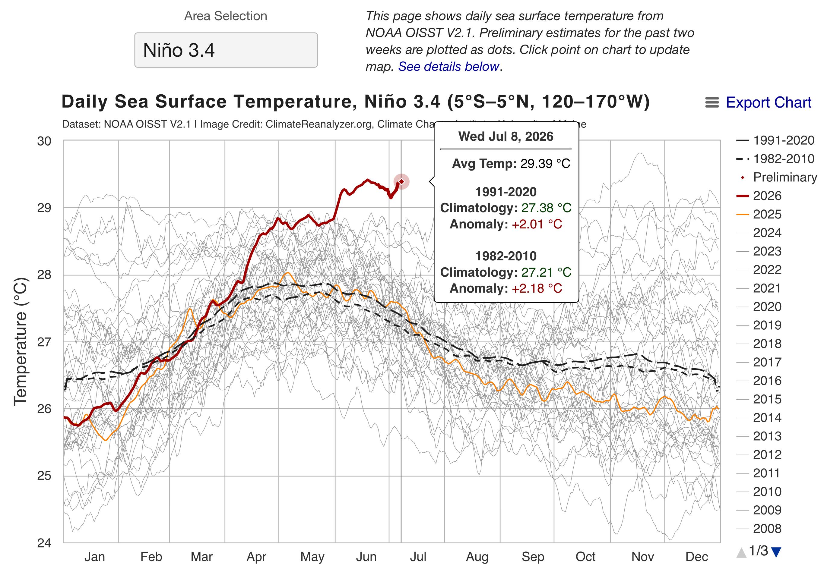
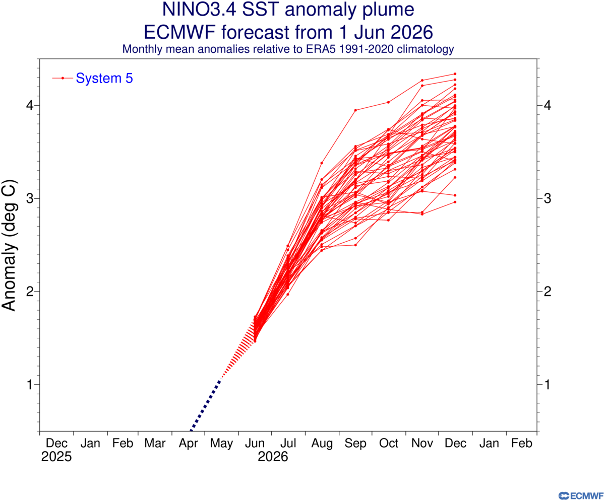
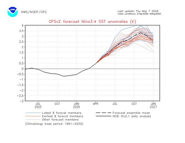
The earliest we reached Super El Niño Status was in August 30, 1997 until we broke that record two days ago on July 8th, 2026. Forecast plumes are predicting between +3.0C and +4.0C above average for Earth on top of the +1.5C that we have accumulated since pre-industrial, which are temperatures that we have never seen before. The extreme weather that is coming will be historical. EL NIÑO/SOUTHERN OSCILLATION (ENSO) DIAGNOSTIC DISCUSSION issued by CLIMATE PREDICTION CENTER/NCEP/NWS 9 July 2026 ENSO Alert System Status: El Niño Advisory Synopsis: El Niño continues and will strengthen through the end of the year, with a 97% chance it will persist through early spring 2027. El Niño strengthened over the past month, with a large area of sea surface temperature anomalies in excess of +1.0°C across the central and eastern equatorial Pacific [Fig. 1]. The latest weekly Niño-3.4 index value was +1.2°C, with the westernmost (Niño-4) and easternmost (Niño-1+2) indices at +0.5°C and +2.7°C, respectively [Fig. 2]. The equatorial subsurface temperature index (average from 180°-100°W) increased [Fig. 3], as a recent downwelling Kelvin wave deepened the thermocline and raised temperatures in the eastern Pacific [Fig. 4]. Low-level westerly wind anomalies and upper-level easterly wind anomalies were observed over the western and central equatorial Pacific. Convection was enhanced over the central and east-central equatorial Pacific and was suppressed over Indonesia [Fig. 5]. The traditional and equatorial Southern Oscillation indices were significantly negative. Collectively, the coupled ocean-atmosphere system reflected a strengthening El Niño. The North American Multi-Model Ensemble (NMME) average, including the NCEP CFSv2 [Fig. 6], forecasts El Niño to intensify through 2026. Alongside model forecasts, a strong coupling of the atmospheric and oceanic circulation across the Pacific contributes to very high confidence that El Niño will continue through early 2027 [Fig. 7]. There is an 81% chance of a very strong El Niño during October-December [Fig. 8] that would rank among the largest El Niño events in the historical record going back to 1950. Even the strongest El Niño events do not lead to the typical impact everywhere, but stronger events can more significantly tilt the odds in favor of expected outcomes (see CPC outlooks for probabilities of seasonal anomalies). In summary, El Niño continues and will strengthen through the end of the year, with a 97% chance it will last through early spring 2027. This discussion is a consolidated effort of the National Oceanic and Atmospheric Administration (NOAA), NOAA's National Weather Service, and their funded institutions. Oceanic and atmospheric conditions are updated weekly on the Climate Prediction Center web site (El Niño/La Niña Current Conditions and Expert Discussions). A probabilistic strength forecast is available here. The next ENSO Diagnostics Discussion is scheduled for 13 August 2026.

-
June 2026 was hottest on record beating June 2024. From June 2023 to July 2024 for 14 consecutive months, earth broke records for warmest months. We will most likely see that record streak extend. June 2026 Global Temperature Update, Warmest June on Record +1.51°C Temperature Mean June (1880-1920)NASA Current Record (2026) (+1.51C) +1.48°C👆 For the Year Hottest year (2024) 1.56c Second hottest year (2025) 1.46c Third hottest year (2023) 1.45c +1.44°C👆 Last 12 Months
-
We have crossed the +2.0C (+2.01C) and Earth is now in a Very Strong (Super) El Niño status. Will take a few months before we start feeling the maximum effects of it.
-
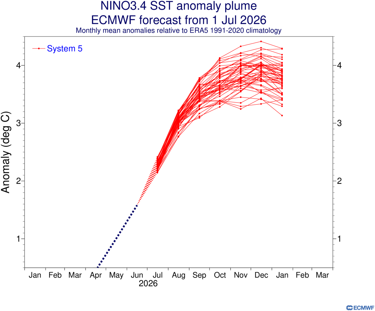
Latest forecast on Nino 3.4, a bit stronger than June’s forecast.
-
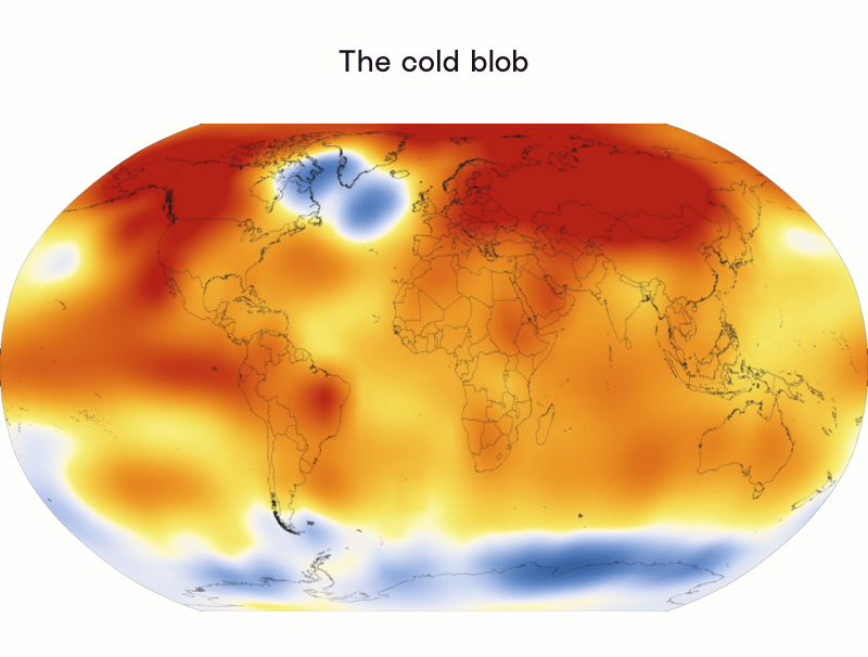
A study released a couple of years ago shows there is a link between Arctic Ice melt and European heatwaves and the coming heatwaves in the US/Canada, and the cold blob that is building by Greenland is all connected. Anthropogenic Global Warming is the blame. https://wcd.copernicus.org/articles/5/109/2024/wcd-5-109-2024.pdf https://www.science.org/content/article/cold-blob-arctic-meltwater-may-be-causing-european-heat-waves
-
 Over 1k Deaths so far and 50k missing latest data
 -
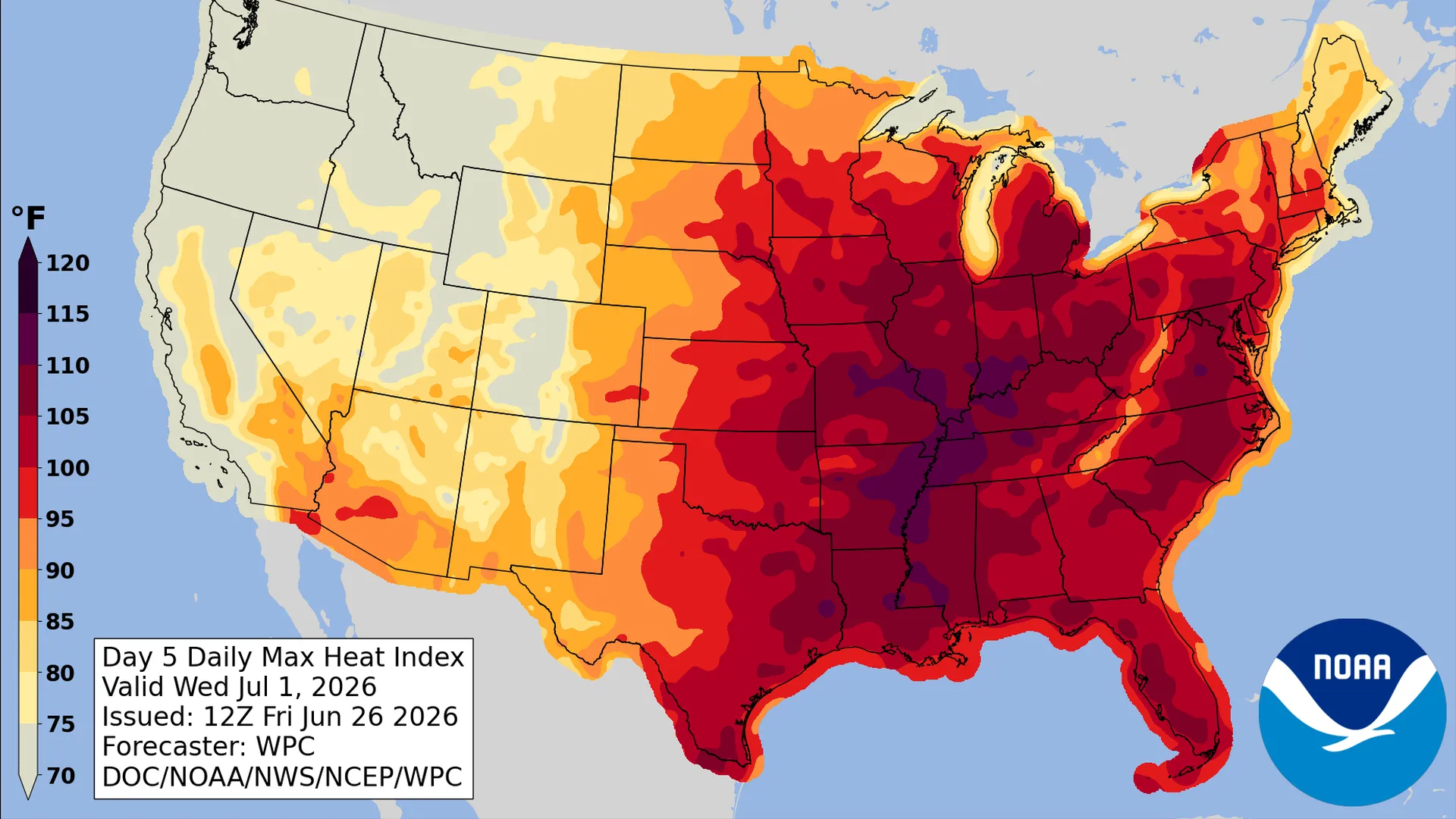
Significant, dangerous heat wave expected next week for the Central to Eastern U.S A dangerous heat dome is expect on the east coast next week according to NOAA. A temperature range between 90-110 with overnight lows to also be very warm bringing little relief.
-
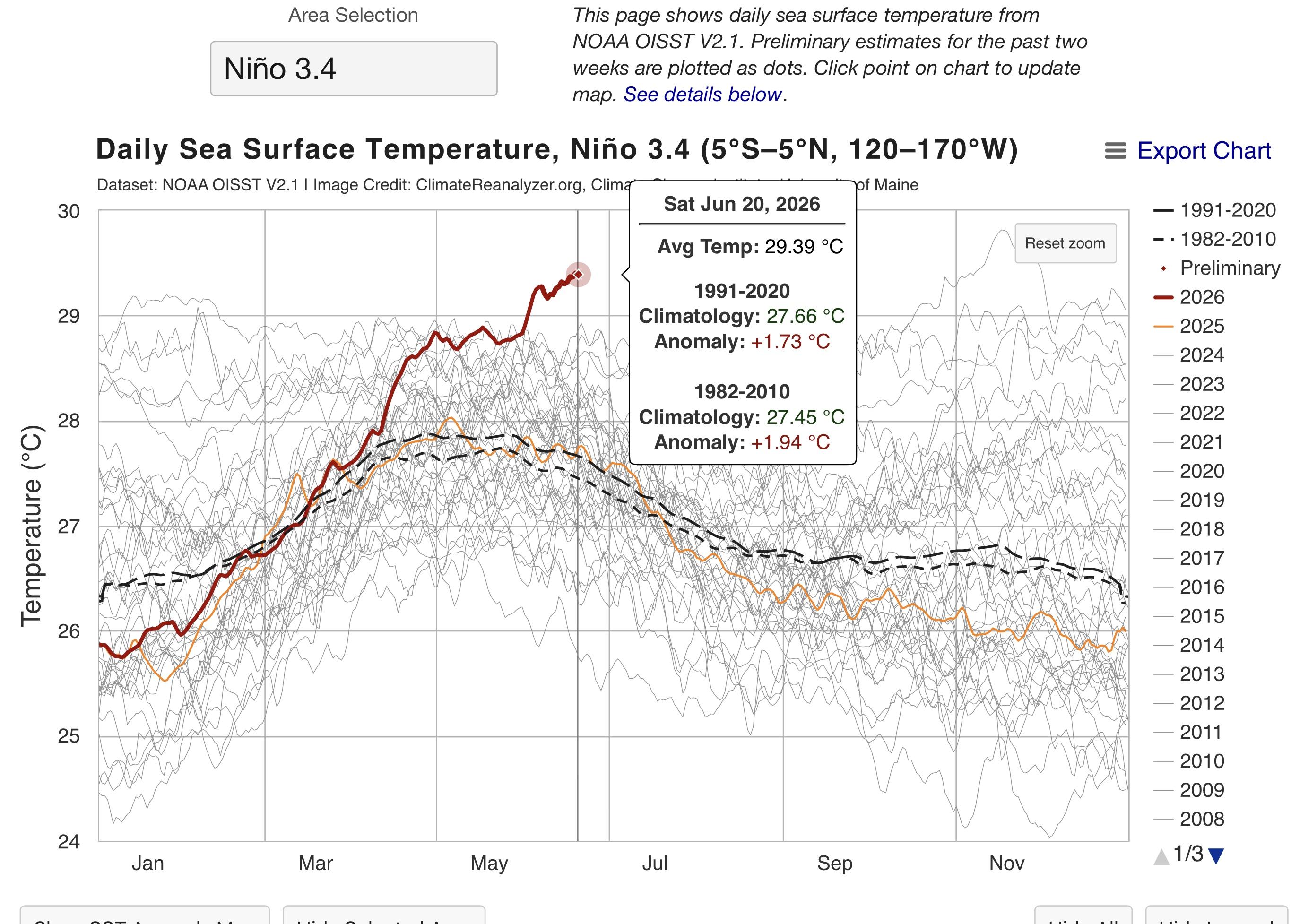
El Niño is at +1.73C as of Saturday, getting close to a Very Strong or Super El Niño Strength (+2.0C).
-
Antarctica now 3rd lowest, losing gains during winter.
-
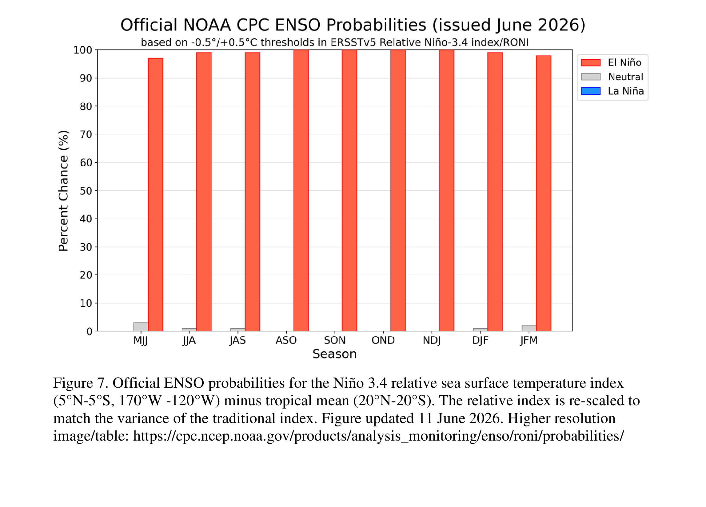
Almost 100% probability from June through March for El Niño, extreme weather around the globe incoming… The Indian Ocean Dipole is looking to be Positive around August, adding to what El Niño is already bringing. EL NIÑO/SOUTHERN OSCILLATION (ENSO) DIAGNOSTIC DISCUSSION issued by CLIMATE PREDICTION CENTER/NCEP/NWS 11 June 2026 ENSO Alert System Status: El Niño Advisory Synopsis: El Niño conditions are present and expected to strengthen into the Northern Hemisphere winter 2026-27. El Niño conditions developed over the past month, as shown by above-average sea surface temperatures (SSTs) across the central to eastern equatorial Pacific Ocean [Fig. 1]. The latest weekly Niño-3.4 index value was +0.7°C, with the westernmost (Niño-4) and easternmost (Niño-1+2) indices at +0.7°C and +2.1°C, respectively [Fig. 2]. The equatorial subsurface temperature index (average from 180°-100°W) decreased in the past month [Fig. 3], but significantly above-average subsurface temperatures remained in the central and eastern equatorial Pacific [Fig. 4]. Low-level westerly wind anomalies and upper-level easterly wind anomalies were evident over the central equatorial Pacific. Convection was slightly above average over the central and east-central equatorial Pacific and was near or below average over Indonesia [Fig. 5]. The traditional and equatorial Southern Oscillation indices were negative. Collectively, the coupled ocean-atmosphere system reflected the onset of El Niño conditions. The North American Multi-Model Ensemble (NMME) average, including the NCEP CFSv2 [Fig. 6], forecasts El Niño to intensify into the Northern Hemisphere winter 2026-27. High confidence in El Niño [Fig. 7] is also linked to anomalously high oceanic heat content and expanding westerly wind anomalies across the equatorial Pacific Ocean. There is a 63% chance of a very strong El Niño during November-January [Fig. 8] that would rank among the largest El Niño events in the historical record going back to 1950. Even very strong El Niño events do not lead to the expected impact everywhere, but stronger events can more significantly tilt the odds in favor of expected outcomes (see CPC outlooks for probabilities of seasonal anomalies). In summary, El Niño conditions are present and expected to strengthen into the Northern Hemisphere winter 2026-27. This discussion is a consolidated effort of the National Oceanic and Atmospheric Administration (NOAA), NOAA's National Weather Service, and their funded institutions. Oceanic and atmospheric conditions are updated weekly on the Climate Prediction Center web site (El Niño/La Niña Current Conditions and Expert Discussions). A probabilistic strength forecast is available here. The next ENSO Diagnostics Discussion is scheduled for 9 July 2026.
-
May 2026 Global Temperature Update, 2nd Warmest May on Record +1.38°C Temperature Mean May (1880-1920)NASA Current record (2024) (+1.43C) +1.47°C👇 For the Year Hottest year (2024) 1.56c Second hottest year (2025) 1.46c Third hottest year (2023) 1.45c +1.43°C👆 Last 12 Months
-
Early stages of coupling between the Atmosphere and the Equatorial Pacific Ocean as the Southern Oscillation Index has reached the El Niño Threshold. https://www.bom.gov.au/climate/enso/?ninoIndex=nino3.4&index=rnino34&period=weekly#tabs=Overview Earth is primed for a historic El Niño.
-
Ocean at record level heat and will probably be at record level for a while.
-
Climate Analyzer is showing that we are in a preliminary stage of Strong Category, the speed of this El Niño is nuts. Only year stronger was in 2015 and that wasn’t until October. There’s no question we will see temperatures over 2.0C and even as high as 3.0C above normal, going to be a wild ride for the next 2 years.
-
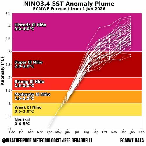
Posted the wrong chart. So the average is more around +3.5C and a few of the plume models showing past +4.0C. Heres a chart made by a meteorologist that shows stripes of various strengths.
-
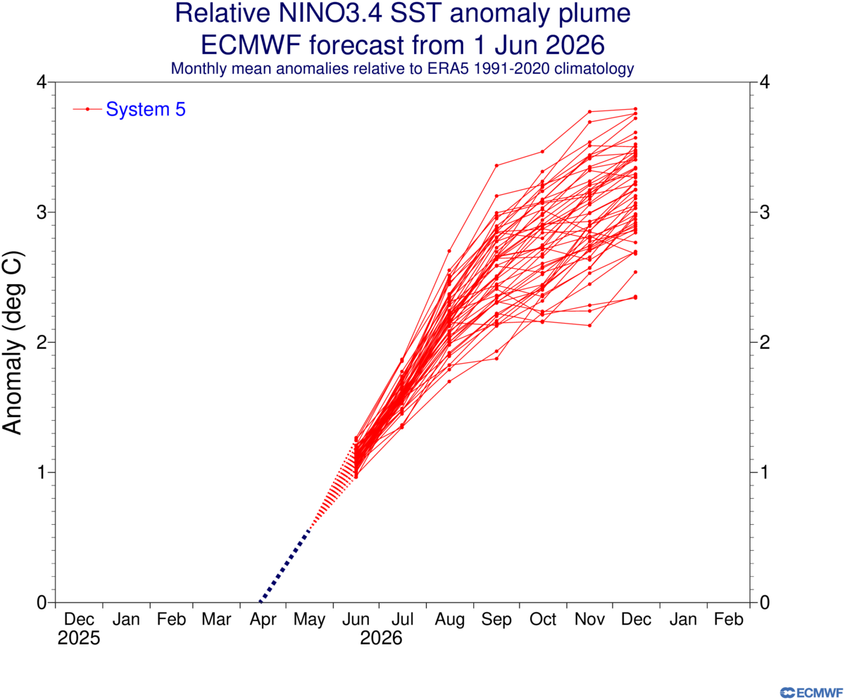
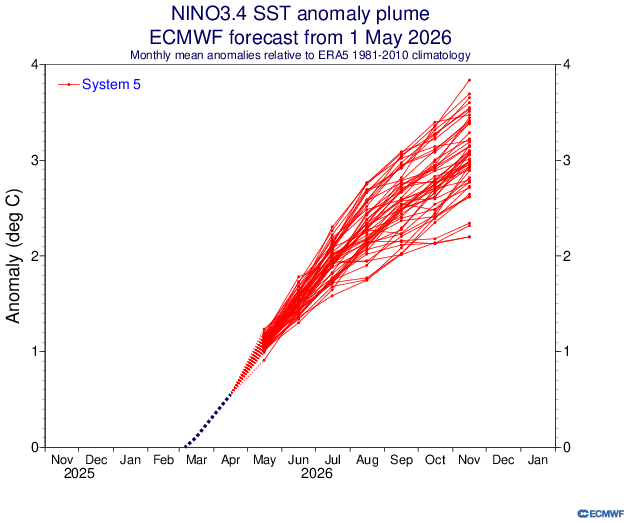
New EMCWF plumes forecast, a bit stronger than the May 1 forecast. The average the models are showing seem to be around the +3.0C above average range which would be historic and into the uncharted territory, and since the spring predictability barrier is pretty much over, this forecast should be taken seriously.
-
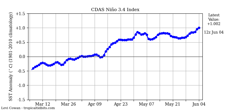
El Niño just crossed the +1.0C line, now at Moderate Strength.
-
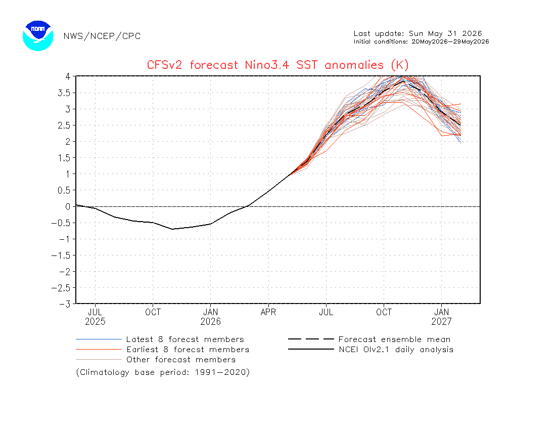
Latest CFSv2 Forecast, This is the biggest forecast ever and this thing continues to grow.
-
This is really big news. The collapsing of the Thwaites Glacier sea Ice Shelf is now Imminent, it is projected to break away from Antarctica this year. The cracks are quite big and visible now. This sea Ice Shelf is no longer holding the Thwaites Glacier back. Once this land Glacier starts flowing off the continent and into the sea as Icebergs, we will start seeing a calamity because it will add sea level rise worldwide. How fast will this happen, don't know. We know it will be happening. Now with this massive El Niño being formed right now, all that heat in the Ocean will just speed things up, Antarctica is now 5th lowest on record. There is a Science Article that posted yesterday about this here. Great Tribulation is right around the corner.
-
EL NIÑO/SOUTHERN OSCILLATION (ENSO) DIAGNOSTIC DISCUSSION issued by CLIMATE PREDICTION CENTER/NCEP/NWS 14 May 2026 ENSO Alert System Status: El Niño Watch Synopsis: El Niño is likely to emerge soon (82% chance in May-July 2026) and continue through Northern Hemisphere winter 2026-27 (96% chance in December 2026-February 2027). In the past month, ENSO-neutral conditions continued, as indicated by near-average sea surface temperatures (SSTs) in the east-central equatorial Pacific Ocean [Fig. 1]. The latest weekly Niño-3.4 index value was +0.4°C, with the westernmost (Niño-4) and easternmost (Niño-1+2) indices at +0.5°C and +1.0°C, respectively [Fig. 2]. The equatorial subsurface temperature index (average from 180°-100°W) increased for the sixth consecutive month [Fig. 3], with widespread, significantly above-average subsurface temperatures across the equatorial Pacific [Fig. 4]. Westerly wind anomalies were observed over the western equatorial Pacific at low levels and were evident over the central and east-central Pacific at upper levels. Convection was near average on the equator near the Date Line and was suppressed around Indonesia [Fig. 5]. Collectively, the coupled ocean-atmosphere system reflected ENSO-neutral conditions. The North American Multi-Model Ensemble (NMME) average, including the NCEP CFSv2 [Fig. 6], favors El Niño to form by next month and persist through Northern Hemisphere winter 2026-27. While confidence in the occurrence of El Niño has increased since last month, there is still substantial uncertainty in the peak strength of El Niño, with no strength categorization exceeding a 37% chance [Figs. 7 & 8]. The strongest El Niño events in the historical record are characterized by significant ocean-atmosphere coupling through the summer, and it remains to be seen whether this occurs in 2026. Stronger El Niño events do not ensure strong impacts; they can only make certain impacts more likely (see CPC outlooks for probabilities of seasonal anomalies). In summary, El Niño is likely to emerge soon (82% chance in May-July 2026) and continue through Northern Hemisphere winter 2026-27 (96% chance in December 2026-February 2027). This discussion is a consolidated effort of the National Oceanic and Atmospheric Administration (NOAA), NOAA's National Weather Service, and their funded institutions. Oceanic and atmospheric conditions are updated weekly on the Climate Prediction Center web site (El Niño/La Niña Current Conditions and Expert Discussions). A probabilistic strength forecast is available here. The next ENSO Diagnostics Discussion is scheduled for 11 June 2026
-
We are on track to be either hottest or second hottest for 2026, I know it doesn't look like it right now, it will take a turn soon. 2026 is trending towards an alignment of all 3 Ocean basins to be positive at the same time, which is a rare event. The Equatorial Pacific Ocean is Positive for 2026 The North Atlantic Oscillation is looking to be headed to positive forecast this year The Indian Ocean Dipole also showing heading to positive forecast this year April 2026 Global Temperature Update, 3rd Warmest April on Record +1.43°C Temperature Mean April (1880-1920)NASA Current record (2024) (+1.59C) Second (2025) (+1.51C) +1.48°C👇 For the Year Hottest year (2024) 1.56c Second hottest year (2025) 1.46c Third hottest year (2023) 1.45c +1.42°C👇 Last 12 Months
-
Once the Kelvin wave reaches max power, it will get crazy hot. That heat Pulse in the Ocean that is coming up that this article is describing is at least 7.0C above normal at minimum, the chart only goes to 7.0C, some experts say it may be as high as 9.0C, thats never been seen before. https://www.severe-weather.eu/long-range-2/super-el-nino-2026-record-breaking-intensity-forecast-weather-impacts-united-states-canada-europe-fa/ A major atmospheric change is about to start, as the latest oceanic data confirms the 2026 El Niño is intensifying below the ocean surface. New ensemble model runs from the ECMWF, NOAA, and BOM now align on a high-impact trajectory, with several forecasts suggesting this event could become the strongest El Niño in modern history, potentially surpassing the record-breaking event of 1877-1878. This “Code Red” scenario for the global atmosphere is being driven by a massive oceanic Kelvin wave that has grown more energetic in recent weeks. This subsurface heat pulse is expected to rise to the surface levels, acting as a “release valve”, that will kickstart the reorganization of global weather patterns, starting in the tropics.
-
Another update by NOAA on the forecast plumes, the forecast keeps increasing, some plumes are hitting 4.0C. This El Niño will be the hottest humans will experience if this model comes through. Guaranteed to be over 2.0C which is a Super El Niño, but looking like we will be over 3.0C.
-
Europe ECMWF released May 1st forecast for El Niño’s Strength. You can compare to the April 1st forecast above.
-
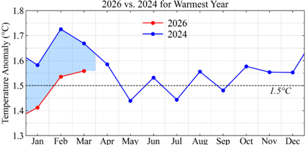
According to Hansen and NASA data, It’s looking like 2026 has a very big chance at toppling 2024 as hottest year based on comparison of 2026 current temperature trend with 2023 recorded data, the 2026 SST shows that it is consistently warmer by 0.13°C than 2023, that gap should be maintained throughout the year if not higher. The temperature change over land exceeds that over ocean by a factor of 2, land covers 30% of the globe, when you include that with the ocean gap of 0.13°C it implies a global warming of 0.17°C greater than 2023 according to GISS analysis. 2024 was greater than 2023 by 0.11°C, so that still makes 2026 greater than 2024 by 0.06°C. 2027 will be record breaking by large margins no matter what happens in 2026. Based on that data mentioned above, we should start seeing that red line crossing above 2024 soon if it is to overtake 2024 as hottest for the year.


About JWTalk.net - Jehovah's Witnesses Online Community
Since 2006, JWTalk has proved to be a well-moderated online community for real Jehovah's Witnesses on the web. However, our community is not an official website of Jehovah's Witnesses. It is not endorsed, sponsored, or maintained by any legal entity used by Jehovah's Witnesses. We are a pro-JW community maintained by brothers and sisters around the world. We expect all community members to be active publishers in their congregations, therefore, please do not apply for membership if you are not currently one of Jehovah's Witnesses.